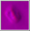
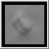
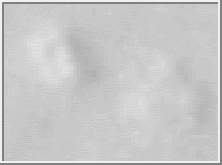
 035a72.gif (575 KBytes)
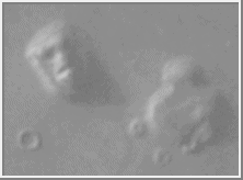
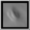
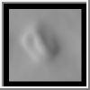
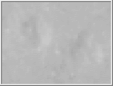
 070a13.gif (491 KBytes)
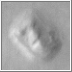
© Copyright 1995 Malin Space Science Systems, Inc.
| Introduction |
|---|
In July, 1976, Viking Orbiter 1 was acquiring images of the Cydonia region of Mars as part of the search for potential landing sites for Viking Lander 2. On 25 July, 1976, it photographed a region of buttes and mesas along the escarpment that separates heavily cratered highlands to the south from low lying, relatively crater-free, lowland plains to the north. Among the hills was one that, to the Viking investigators scrutinizing the images for likely landing sites, resembled a face. Owing to the importance of the landing site search, and with a desire to provide the public with at least one familiar-looking landform amid the craters and exotic terrains found all over Mars, an image including the face-like hill was released as part of the Jet Propulsion Laboratory's public relations effort. The text of that release notes the face-like hill.
Subsequent to this release, some people have argued, mostly in the lay literature, that the face-like hill is artificially shaped. Although their argument has been expanded to a host of nearby features, none commands public interest like the "Face." This page will provide interested persons with both the raw Viking images, transformed to GIF format, and a brief tutorial (with examples) of image processing techniques applied to create "better looking" images.
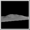
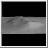
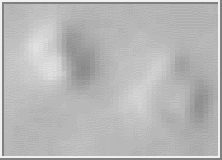
The Raw Images
Table 1, below, lists all Viking Orbiter images of the "face," in
order of decreasing resolution. Following the table are the images
acquired at resolutions better than 400 meters/pixel. The icons show
the "face" as seen in the raw data, but contrast enhanced for
visibility. The actual images have not been processed other than
conversion to GIF format. As a reminder, each raw Viking Orbiter
image is 1204 samples wide by 1056 lines high.
| PicNo | Resolution | PicNo | Resolution |
|---|---|---|---|
| *070A13 | 43 m | 753A06 | 588 m |
| *035A72 | 47 m | 753A03 | 596 m |
| *561A25 | 163 m | 717A04 | 723 m |
| *673B56 | 226 m | 771A94 | 735 m |
| 673B54 | 226 m | 257S41 | 780 m |
| *753A34 | 233 m | 220S38 | 808 m |
| 753A33 | 233 m | 257S69 | 821 m |
| 753A05 | 578 m | 220S37 | 863 m |
| 859A05 | 582 m | 590A24 | 889 m |
035a72.gif (575 KBytes)
070a13.gif (491 KBytes)
 561a25.gif (451 KBytes)
 753a34.gif (602 KBytes)
Label Information (Ancillary Data)
| PICNO | #lines | #samples |
|---|---|---|
| 035A72 | 2135 | 1973 |
| 070A13 | 1899 | 1669 |
| 561A25 | 1552 | 1729 |
| 673B56 | 1757 | 1611 |
| 753A34 | 2129 | 1980 |
Map Projected Images
 035a72m.gif (1.4M)
Topography
Derivation of a model of the relief of an object from the way it
reflects light seems reasonably straightforward: slopes facing a light
source appear brighter than those facing away. However, in practice
this is a difficult problem to solve, and the results are often
non-unique. Based on the computer vision literature, MSSS scientists
have developed a "shape-from-shading" technique that can be applied to
planetary images. The following images are the vertically viewed
height field (exaggerated to fill an 8-bit, 255-level range) and a
stereoscopic view of the original image draped over the height field
in both stereopair and anaglyph form.
 Topography (GIF = 38 KBytes)
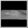
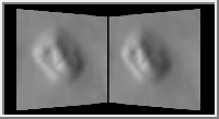 Stereopair (GIF = 52 KBytes)
 Anaglyph (GIF = 19 KBytes)
Changes of Appearance with Illumination Direction
Using the height field, it is possible to view, at the admittedly
lower spatial resolution of that field, what the "Face" looks like under
different illumination conditions, in particular from illumination at
different hour angles. Since the "Face" is above the martian "Tropic
of Capricorn" (+25 deg), illumination in reality will always be from
a southernly direction, but in these simulations, illumination can
come from other directions as well.
 Illumination from southwest (GIF = 22 KBytes)
 Illumination from south (GIF = 18 KBytes)
 Illumination from northeast (GIF = 22 KBytes)
 Illumination from north (GIF = 18 KBytes)
 MPEG of 360 deg rotation of
illumination direction (MPEG = 79 KBytes)
MPEG of 360 deg rotation of
illumination direction (MPEG = 79 KBytes)
Changes of Appearance with Viewing Direction
Using the height field, it is also possible to view the "Face" from
different look directions, by mapping the Viking Orbiter image
directly on the the topography and then placing the "viewer" at
different locations.
 View from southwest (GIF = 12 KBytes)
 View from south (GIF = 16 KBytes)
 View from northeast (GIF = 10 KBytes)
 View from north (GIF = 17 KBytes)
 MPEG of 360 rotation of viewing
direction (MPEG = 70.2 KBytes)
MPEG of 360 rotation of viewing
direction (MPEG = 70.2 KBytes)


 Mars
Mars