 Venusian Volcanic Features
 Venusian Volcanic Features

Volcanic features are numerous and widely scattered on Venus. These features include widespread lava plains, extensive flows, lava channels, small shields, cones, domes, intermediate to large shields, and caldera-like structures not associated with shield volcanoes. Scientists suspect that some volcanoes are still active; however, clouds from volcanic erruptions are invisible to radar. In order to detect volcanic activity, scientists must compare images taken at different times and look for changes on the planet's surface.
The majority of volcanic materials on Venus are thought to be basaltic in composition, partly because of their appearence. This view is supported to some extent by data returned from the Soviet Vega and Venera space probes [Barsukov et al., 1982 and 1986].
Volcanic plains typically cover large lowland areas separated by mountains or ridge belts; they extend over 85% of the planetary surface. The plains range in elevation from about 1.5 kilometers (.9 miles) below to 2 kilometers (1.2 miles) above the mean planetary radius of 6,051 kilometers (3,761 miles) [Guest et al., 1992]. They consist of extensive sheets of flood lavas hundreds of kilometers in width and mostly 100 to 700 kilometers (62 to 430 miles) in length. Some plain regions are bright in radar images, but most are dark, indicating a smooth surface.
Lava flows may extend from a few to hundreds of kilometers in length. They can originate from volcanoes, cracks in the crust and depressions in the surface. Often, the sources of the flood lavas are unseen.
Lava flows can be characterized by smooth surfaces and the presence of channels, levees, pressure ridges, flow margins, and flow directions. These characteristics provide important information about lava flow formation and the underlying topography. Many flows contain small volcanic shields and cones.
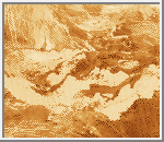 Lava Flow Field South of Ozza Mons
(GIF, 694K)
A flow field south of Ozza Mons in Atla Regio
consists of numerous adjacent and
overlapping flows with varying degrees of brightness.
Brightness in radar images is related to several factors such as surface
roughness, emissivity and the dielectic constant of the material.
Emissivity is a measure of how well an object approximates a perfect
blackbody radiator. It is
controlled primarily by the
dielectric constant.
Material of high dielectric constant is generally a good reflector.
(Image Credit: Calvin J. Hamilton)
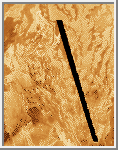 Flow fields of Mylitta Fluctus in Lavinia Planitia
(GIF, 392K)
Mylitta Fluctus is a complex of six flow fields in the southern hemisphere
of Venus [Roberts et al., 1992]. The area is similar in size to the
Columbia River flood basalt province on Earth. Each flow field is
composed of numerous individual flows. Many of the flows are
hundreds of kilometers long, comparatively narrow (tens of kilometers),
Many scientists believe the flow fields are generally
basaltic in composition [Campbell and
Campbell, 1992].
(Image Credit: Calvin J. Hamilton)
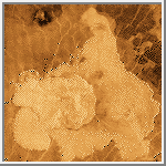 Festoon Flows
(GIF, 2M)
A volcano on the plains between Artemis Chasma and Imdr Regio
displays a sheet of thick radar-bright flows and broad flow lobes.
This type of flow has been name "festoon" and only three
have been found on Venus [Head et al., 1992]. The
lobes and flows show prominent transverse ridges that have an average
spacing of about 750 meters (2,460 feet). The flow features are associated
with a complex domical structure about 100 kilometers (62 miles)
across and 1 kilometer (.6 miles) in relief.
They are surrounded at a lower elevation by plains
surfaces that expose radar-bright volcanic deposits
[Moore et al., 1992]. These materials extend some 360 to 400 kilometers
(220 to 250 miles) from the volcano. They appear to overlie the radar-dark,
lowland plains that dominate this region of the surface.
(Image Credit: Calvin J. Hamilton)
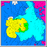 Festoon Flow Diagram
(GIF, 76K)
This diagram shows the volcano
broken down into six types of regions. Measurements indicate
that in the ridged mesas the
scarps have relief up to 205 meters
(673 feet); in the lobate mesas,
the relief is from 133 to 723 meters (436 to 2,372 feet).
(Image Credit: Calvin J. Hamilton)
Lava channels extending from hundreds to thousands of kilometers in length are conspicuous on the Venusian plains. Simple channels typically show little or no branching. They include long sinuous forms, termed "canali", and sinuous rilles. Canali are best preserved in regions of subdued relief. They have a high width-to-depth ratio and maintain a remarkably constant width over very long distances. Images reveal the presence of meanders, point bars, cut banks, and abandoned channel segments.
Both the source and the distal ends of many canali are buried or extensively subdued by lava flows younger than those that formed the channels. Measurements have shown considerable relief in longitudinal channel profiles, implying significant tectonic deformation of the plains since the channels formed [Parker et al., 1992]. Wrinkle ridges and ridge belts commonly transect canali. Vertical displacements of hundreds of meters over horizontal distances of a few kilometers are common at ridge crossings.
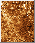 Sinuous Channel
(GIF, 158K)
A Sinuous segment of a simple radar-dark channel about 200 kilometers
(120 miles) long and 2 kilometers (1.2 miles) wide is shown in this image.
Channel outlines at both ends are indistinct, probably because of
infilling by younger lavas. Thin bright returns from channel walls denote
steep slopes. A transecting relict
channel of approximately similar width is denoted by parallel bright
margins (levees) that cross the lava plains in a northwest direction on
each side of the radar-dark channel.
(Image Credit: Calvin J. Hamilton)
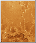 Sinuous Rilles
(GIF, 579K)
Sinuous rilles emanate from depressions and enlarged fractures south
of Ovda Regio. They become progressively narrower and more shallow in
the downstream direction. They are typically 1
to 2 kilometers (.6 to 1.2 miles) wide and tens to hundreds of kilometers in length.
Channel walls form a distinct boundary between the channel floor and the surrounding
terrain. Channel material is similar to that of the surrounding terrain.
An impact crater about 12 kilometers (7.5 miles) in diameter has disrupted the eastern
channel at center right.
(Image Credit: Calvin J. Hamilton)
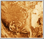
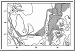 Ammavaru Lava Flows & Topography
(GIF, 1M;
GIF, 109K)
This is a mosaic of the Ammavaru volcanic complex and associated
outflow channel in the Lada Terra region.
The channel displays a broad
U-shaped outline across the image that extends from a collapse source
on the southwest flank of Ammavaru (upper left), through reaches that
are anastomosing (lower left center) and distributary (lower center), to
terminal flow deposits east of a breach in the north-trending ridge
(upper right). The channel is more than 1,200 kilometers (750 miles) long.
(Image Credit: Calvin J. Hamilton)
The southern, topographically lower end of the trough was flooded with lavas that appear radar-dark in the image. At 51.5° S, 25.5° E, the flood spreads into a broad anastomosing reach. East of the highlands at this locality the channel branches into a distributary reach for about 130 kilometers (80 miles). Three radar-dark distributaries change to radar-bright with dark margins about midway along this reach. Bright flow deposits with lobate morphology are extensively distributed here. The deposits are ponded on the west side of a north-trending ridge belt for over 300 kilometers (186 miles). The main distributary channel extends through these deposits and terminates eastward at an extensive radar-bright plain east of a breach in the ridge belt. The radar-bright deposits from the outflow channel cover an area of about 100,000 km2; they show broad lobate margins typical of lava flows.
 Ammavaru Outflow Channel
(GIF, 795K)
This image shows the collapse source and the upper reach of outflow
channel on southwest flank of the volcano Ammavaru. The main channel,
about 5.5 kilometers (3.4 miles) wide, is contained
within a linear trough that extends south-southeast for about 300 kilometers
(186 miles). A subsidiary channel about 1 kilometer (.6 miles) wide
divides at the south limit of a linear
scarp and reunites farther downstream.
(Image Credit: Calvin J. Hamilton)
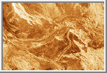 Ammavaru - Anastomosing Reach of Outflow Channel
(GIF, 651K)
Anastomosing reach of outflow channel shows streamlined islands that
point eastward in the flow direction of the lava deposits. Radar-dark
embayments in highland areas denote lava ponding and flooding that
occurred prior to eastward channel cutting and the formation of the
distributary reach east of the highlands (right center).
(Image Credit: Calvin J. Hamilton)
Volcanic constructs and edifices on Venus have been classified and subdivided on the basis of their size and morphology [Slyuta and Kreslavsky, 1990; Head et al., 1992]. Centers with a diameter less than 20 kilometers (12 miles) are considered small. They occur typically on the plains, but are also found on the flanks of large volcanoes and in association with coronae and arachnoids. They consist of small shields, cones, and some domes.
6mall shields have circular to elongated outlines. In general, they have very shallow slopes and are not associated with flow deposits. Many small shields have been identified by their smooth circular outlines and image tones that are darker than the surrounding plains. The outlines may also be diffuse and may be distinguished by the presence of a centrally located, circular summit pit about 1 kilometer (.6 miles) or less in diameter. Clusters of small shields approximately 10 kilometers (6 miles) in diameter are widely distributed, often in association with linear fracture belts on the plains.
Cones are circular features with steep slopes and a centrally located summit pit. They range in height from 200 to 1,700 meters (660 to 5,600 feet) with slopes from 12 to 23 degrees. Individual flows are not usually visible. Cones tend to occur in clusters on the plains. A temporal relation between cones or shields in a cluster and fractures on the plains is evident in cases where some of the cones or shields are cut by fractures and therefore are older. Other cones or shields in the cluster are superposed on the fractures and thus are younger.
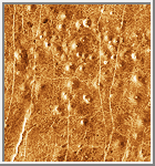 Cluster of Cone Volcanoes
(GIF, 588K)
The cone volcanoes in this cluster are about 2 kilometers (1.2 miles)
in diameter, 200 meters (660 feet) high, with 12°
steep slopes overlying a fracture network in Niobe
Planitia. Some cones are cut
by younger, more widely spaced, north-striking fractures with
curvilinear outlines.
(Image Credit: Calvin J. Hamilton)
Intermediate volcanoes are defined as centers between 20 to 100 kilometers (12 to 62 miles) in diameter. Typically they consist of relatively symmetrical shields characterized by radial lava flows and fracture patterns. Domes are prominent features in this size class.
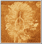 Anemone Type Volcano
(GIF, 957K)
Scientists have named this type of volcano "anemone" because
of its petallike lava flows and radiating radar-bright patterns.
They normally occur in association with fissure type erruptions.
This volcano is 40 by 60 kilometers (25 by 37 miles) in size and has a dark central edifice with bright central flows. It has elongated summit pits and an arcuate
graben along the southern summit [ Head et al., 1992].
(Image Credit: Calvin J. Hamilton)
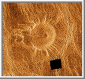 Tick
(GIF, 154K)
Scientists nicknamed this type of volcano a tick. About 65.6 kilometers
(41 miles) across at the base, this volcano has a flat, concave summit
34.8 kilometers (22 miles) in diameter. The sides of the volcano are characterized
by radiating ridges and valleys. The rim of the volcano to the west
appears to have been breached by dark lava flows that emanated from a
shallow summit pit 5.4 kilometers (3.4 miles) in diameter and traveled west along
a channel. A series of coalescing, collapsed pits 2 to 10 kilometers (1.2 to 6.2 miles)
in diameter is 10 kilometers (6.2 miles) west of the summit rim. The black square
represents missing data.
(Courtesy NASA/JPL)
The majority of Venusian domes range in diameter from less than 10 kilometers (6.2 miles) to about 100 kilometers (62 miles) with a mean of about 24 kilometers (15 miles). Their height range from 70 to 2000 meters (230 to 6,600 feet) with a mean of about 700 meters (2,300 feet) above the surrounding terrain. They are usually surrounded by a steep perimeter and have a relatively flat top. Images reveal that these features are remarkably circular in outline. The surfaces are slightly rough and have a slightly lower reflectivity and correspondingly higher emissivity than the surrounding terrain. They may have formed from viscous lava that erupted uniformly from a central vent [Pavri et al., 1992].
Small craters are a common feature of the surfaces of all domes; they may or may not be central. Breakouts occur on the flanks of some domes and radial fractures extend down the slopes into the surrounding plains. Many domes show evidence of gravitational collapse, slumping, tectonism, impact, and lava flooding.
Domes occur singly, in pairs, groups, or overlapping clusters. Many are associated with coronae, but the eruptive mechanism is not clearly understood. The domes are concentrated at elevations near or just below the mean planetary radius of 6052 kilometers.
 Pancake Volcanoes
(GIF, 197K)
This cluster of four overlapping domes is located on the eastern
edge of Alpha Regio. The domes average about 25
kilometers (16 miles) in diameter with maximum heights of 750 meters
(2,460 feet). These features can be interpreted as viscous or thick
eruptions of lava coming from a vent
on the relatively level ground
allowing the lava to flow in an even lateral pattern.
(Courtesy NASA/JPL)
Some volcanic domes have steep scalloped margins. The outline of the scallops and the presence of debris aprons in places around the margins suggests that the scallops were formed by slope failure. In addition, scalloped-margin domes are often surrounded by concentric fractures.
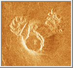 Small Dome in Navka Planitia
(GIF, 163K)
This 17.4 kilometers dome in Navka Planitia shows collapsed margins and
landslide deposits in both the northwest and the northeast quadrants.
The landslide deposits show hummocky surfaces that extend up to 10 kilometers
(6.2 miles) out on the plains. The dome is about 1.86 kilometers (1.2 miles)
high and has a slope of
about 23°. In general, the scale of lava domes and collapse
features on Venus is orders of magnitude larger than that on Earth.
(Image Credit: Calvin J. Hamilton)
Large volcanoes have diameters mostly in the 100 to 600 kilometer (62 to 370 mile) range. Such edifices are characterized by a dominance of radial lava flows in association with positive topography. They occur mostly at higher elevations in broad rises and at tectonic junctions.
 Sapas Mons
(GIF, 745K)
Sapas Mons is a large volcano approximately 400 kilometers (250 miles)
in diameter and 1.5 kilometers (.9 miles) high located on a topographic rise
in Atla Regio. The summit consists of two
mesas with flat to slightly
convex tops and smooth surfaces that appear radar-dark in the image.
The sides of the volcano show numerous bright overlapping flows that
provide the edifice with a roughly radial outline. Many of the flows
appear to be flank eruptions. Radial fractures clearly transect the
flows to the east and south. Darker flows in the southeast quadrant are
probably smoother than the bright flows closer to the eruptive center.
(Image Credit: Calvin J. Hamilton)
An impact crater with a diameter of 20 kilometers (12 miles) located in the northeast quadrant is partially buried by lava flows. A medium-to-light gray flow appears to be ponded to the west by the crater. This flow has been diverted south and east where it has buried a portion of the hummocky ejecta on the southeast side of the crater.
Calderas on Venus have been defined as circular to elongate depressions not associated with well-defined edifices. Characteristically they show the concentric patterns of surrounding fractures [Head et al., 1992]. They may lie in a broad region of elevated topography. They are distinct from impact craters in lacking a hummocky raised rim and an associated ejecta pattern.
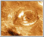 Sacajawea Patera
(GIF, 717K)
Sacajawea Patera is an elliptical
caldera measuring 260 by 175
kilometers (160 to 109 miles) that forms
a depression about 2 kilometers (1.2 miles) deep.
The depression is enclosed by a zone of concentric troughs that show
radar-bright outlines extending from 60 to 130 kilometers (37 to 80 miles) outward from the
caldera floor. The floor is covered with smooth mottled plains. The
brightest deposits occur around the periphery and near the center of the
caldera floor where there is a ponded leveed flow. Linear to sinuous
scarps show bright outlines that extend southeast from the eastern
margin of the caldera. A small shield measuring 12 kilometers (7.4 miles) in diameter
is transected by one of these features.
(Image Credit: Calvin J. Hamilton)

References and Credits
This article was abstracted from Ford [1993], chapter 9 by John P. Ford,
Jeffrey J. Plaut, and Timothy J. Parker.
Barsukov, V. L. et al. "The crust of Venus: Theoretical models of chemical and mineral composition." Proceedings, Lunar Planetary Science Conference 13th, Journal Geophysical Research, v. 87, p. A3-A9, 1982.
Barsukov, V. L.,Yu. A. Surkov, L. Dimitriev, and I. L. Khodakovsky. "Geochemical study of Venus by landers of Vega-1 and Vega-2 probes." Geokhimiya, p. 275-289, 1986 (in Russian).
Campbell, B. A. and D. B. Campbell. "Analysis of volcanic surface morphology on Venus from comparison of Arecibo, Magellan, and terrestrial airborne radar data." Journal of Geophysical Research, v. 97, no. E10, p. 16,293-16,314, 1992.
Ford, John P. et al. Guide to Magellan Image Interpretation. JPL Publication 93-24, p. 109-134, 1993.
Greeley, R. "The Snake River Plain, Idaho: Representative of a new category of volcanism." Journal of Geophysica; Research, v. 87, p. 2705-2712, 1982.
Guest, J. E. et al. "Small volcanic edifices and volcanism in the plains of Venus." Journal of Geophysical Research, v. 97, no. E10, p. 15,949-15,966, 1992.
Head, J. W. et al. "Venus volcanism: Classification of volcanic features and structures, associations, and global distribution from Magellan data." Journal of Geophysical Research, v. 97, no. E8, p. 13,153-13,197, 1992.
Moore, H. J. et al. "An unusual volcano on Venus." Journal of Geophysical Research, v. 97, no. E8, p. 13,479-13,493, 1992.
Parker, T. J. et al. "Longitudinal topographic profiles of very long channels in Venu-sian plains regions." Lunar and Planetary Science Conference 23rd, Lunar and Planetary Instititue, Houston, Texas, p. 1035-1036, 1992.
Pavri, B. et al. "Steep-sided domes on Venus: Characteristics, geologic setting, and eruption conditions from Magellan data." Journal of Geophysical Research, v. 97, no. E8, p. 13,445-13,478, 1992.
Roberts, K. M. et al. "Mylitta Fluctus, Venus: Rift-related, centralized volcanism and the emplacement of large-volume flow units." Journal of Geophysical Research, v. 97, no. E10, p. 15,991-16,015, 1992.
Slyuta, E. N. and M. A. Kreslavsky. "Intermediate-sized (20-100 kilometers diameter) volcanic edifices on Venus." Proceedings Lunar and Planetary Science Conference 21st, Lunar and Planetary Institute, Houston, Texas, p. 1174-1175, 1990.

